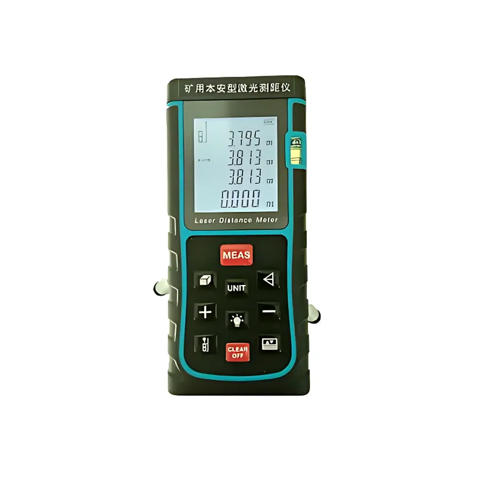
YHJ-100J(A) Intrinsically Safe Mining Laser Distance Meter
| Origin | Beijing |
|---|---|
| Manufacturer Type | Distributor |
| Origin Category | Domestic (China) |
| Model | YHJ-100J |
| Price Range | USD 280–560 |
| Product Type | Handheld |
| Operating Principle | Time-of-Flight Laser Ranging |
| Measurement Range | 0.05–100 m |
| Accuracy | ±1.5 mm |
| Resolution | 1 mm |
| IP Rating | IP54 |
| Laser Class | Class II, 635 nm, ≤1 mW |
| Battery | 2 × 1.5 V AA (up to 8,000 measurements) |
| Auto Power-Off | 3 min |
| Laser Standby Timeout | 30 s |
| Memory Capacity | 20 measurement groups |
| Bluetooth Range | 10 m |
| Tilt Sensor Range | ±65° |
| Tilt Accuracy | ±0.5° |
| Operating Temperature | –10°C to +50°C |
| Storage Temperature | –20°C to +60°C |
| Storage Humidity | <80% RH |
| Mounting Thread | Standard 1/4″-20 UNC tripod socket |
| Certifications | MA (Mine Safety Mark), Ex ib I Mb explosion-proof certification, CNAS-accredited test report |
Overview
The YHJ-100J(A) Intrinsically Safe Mining Laser Distance Meter is a certified handheld distance measurement instrument engineered for high-reliability operation in hazardous underground mining environments. Built to comply with China’s mandatory safety standards for coal mine equipment, it employs time-of-flight (ToF) laser ranging technology at 635 nm (Class II, ≤1 mW) to deliver precise, non-contact linear distance measurements from 0.05 m to 100 m. Its intrinsically safe design—certified under Ex ib I Mb classification per GB 3836.4—ensures zero risk of ignition in methane- or coal-dust-laden atmospheres. The device integrates a high-stability MEMS tilt sensor (±65° range, ±0.5° accuracy) and digital inclinometer functionality, enabling slope-compensated distance calculation, vertical height derivation, and real-time angle-assisted layout verification. Unlike general-purpose consumer-grade laser meters, the YHJ-100J(A) undergoes rigorous environmental stress testing—including thermal cycling, drop impact (1.2 m onto concrete), and electromagnetic compatibility (EMC) validation—to meet the mechanical robustness requirements of ISO 9001-certified mine instrumentation supply chains.
Key Features
- Intrinsically safe architecture compliant with GB 3836.1/4–2021 and certified with MA mark (Mine Safety Approval) and Ex ib I Mb explosion protection rating for use in Zone 0/1 gas and Zone 20/21 dust hazard areas.
- High-resolution ToF laser engine delivering ±1.5 mm accuracy across full 0.05–100 m range, with 1 mm digital resolution and automatic unit switching among meter, inch, and foot outputs.
- Dual-sensor fusion system: integrated tilt sensor (±65°, ±0.5°) enables Pythagorean mode, area/volume calculation, and continuous slope-corrected distance tracking without external leveling tools.
- IP54-rated enclosure constructed from anti-static, shock-absorbing ABS engineering plastic; tactile soft-rubber keypad enhances grip and operational reliability under wet, oily, or gloved-hand conditions.
- Onboard memory stores up to 20 grouped measurement sessions (including timestamps, angles, and derived values); data export via Bluetooth 4.0 (up to 10 m line-of-sight) to Android/iOS field apps or Windows-based survey software.
- Intelligent power management: auto-shutdown after 3 minutes of inactivity; laser deactivation after 30 seconds of idle emission; dual AA alkaline batteries support ≥8,000 single-distance measurements per set.
- Integrated bubble level, acoustic feedback (programmable beep), and one-button self-calibration routine traceable to internal reference baseline—no external calibration kit required for routine field verification.
Sample Compatibility & Compliance
The YHJ-100J(A) is validated for direct use on common mine surface materials including damp rock faces, steel mesh supports, conveyor structures, timber sets, and sprayed concrete linings. Its 635 nm red laser beam maintains sufficient reflectivity even on low-albedo, rough-textured, or moderately soiled targets typical in active excavation zones. All electrical interfaces—including Bluetooth radio, battery compartment, and push-button actuation—are isolated and current-limited per intrinsic safety limits defined in GB/T 18380.33 and IEC 60079-11. The device carries formal third-party test reports accredited by CNAS (China National Accreditation Service for Conformity Assessment), confirming compliance with GB/T 2423 (environmental testing), GB/T 17626 (EMC immunity), and AQ 1048–2007 (safety requirements for coal mine instruments). It satisfies documentation traceability requirements under GLP-aligned mine survey QA protocols and supports audit-ready data logs when used with compatible enterprise survey platforms.
Software & Data Management
Measurement records are structured as timestamped JSON-compatible entries containing raw distance, tilt angle, operating mode (e.g., “Pythagorean”, “Area”, “Max/Min”), and derived metrics (e.g., horizontal distance, vertical rise, surface area). Bluetooth communication uses standard RFCOMM serial profile, enabling seamless integration with custom-developed mine asset management systems or off-the-shelf GIS applications such as ESRI Field Maps or QGIS Mobile. Firmware updates are delivered via signed binary packages through the companion PC utility, which enforces cryptographic signature verification prior to installation—supporting integrity controls aligned with IEC 62443-3-3 SL2 cybersecurity recommendations for industrial field devices. Audit trails include firmware version, calibration status flag, and last self-test timestamp, meeting basic traceability expectations for ISO/IEC 17025-compliant metrology workflows.
Applications
- Underground roadway convergence monitoring: repeated cross-sectional profiling using fixed tripod mounting and tilt-compensated multi-point capture.
- Coal seam thickness estimation via triangulated roof-to-floor measurement in development headings.
- Support pillar spacing verification and alignment checks during bolting or mesh installation.
- Stockpile volume approximation using sequential perimeter and height scans linked to CAD-based modeling tools.
- Emergency egress route validation: rapid clearance height mapping along escapeways and refuge chamber access paths.
- Pre-shift equipment positioning checks—e.g., verifying minimum safe distances between continuous miners and roof bolters.
FAQ
Is the YHJ-100J(A) approved for use in gassy coal mines?
Yes. It holds the MA (Mine Safety) product safety mark and Ex ib I Mb certification per GB 3836.4–2021, authorizing deployment in methane-rich environments classified as Zone 0 (continuous hazard) and Zone 1 (occasional hazard).
Does it require annual recalibration by an accredited lab?
No. Its internal self-calibration routine—verified against factory-traceable reference standards—fulfills routine verification requirements under AQ 1048–2007. External recalibration is recommended only after physical impact or exposure to extreme thermal shock (>80°C or <–30°C).
Can measurement data be exported in CSV format?
Yes. When paired with the official Windows desktop utility, logged sessions export to UTF-8 encoded CSV files containing columns for timestamp, raw distance, tilt angle, mode ID, and calculated result.
What is the maximum effective range on a dark, non-reflective rock face?
Under typical underground lighting (≤50 lux), the practical limit reduces to ~60 m on matte black shale or heavily oxidized steel. For critical long-range work, use the included reflective target plate to restore full 100 m capability.
Is tripod mounting supported?
Yes. A standard 1/4″-20 UNC threaded socket is recessed into the base housing, allowing secure attachment to survey tripods, magnetic mounts, or custom jigs without compromising intrinsic safety integrity.