Dynamax SapIP-MICRO Microclimate Monitoring Network
| Brand | Dynamax |
|---|---|
| Origin | USA |
| Model | SapIP-MICRO |
| Instrument Type | Wireless Mesh-Based Environmental Monitoring System |
| Data Transmission | LoRaWAN / Cellular (SPIP-CELL optional) |
| Network Topology | Self-Healing Mesh |
| Max Nodes per Network | 25 |
| Inter-Node Range | 300–500 m (line-of-sight, SPIP-24K radio) |
| Operating Temperature | −40 to +70 °C |
| Relative Humidity Range | 0–100 % RH |
| Accuracy | ±3 % RH (0–90 % RH, 20 °C), ±5 % RH (90–100 % RH) |
| Air Temperature Range | −40 to +60 °C |
| Accuracy | ±0.6 °C |
| Solar Radiation Range | 0–2000 W/m² |
| Spectral Response | 360–1120 nm |
| Absolute Accuracy | ±5 % |
| Rainfall Resolution | 0.25 mm |
| Accuracy | ±4 % or ±1 tip (0.2–50.0 mm/hr) |
| Wind Speed Range | 0–50 m/s |
| Accuracy | ±0.5 m/s |
| Wind Direction Range | 0–360° |
| Accuracy | ±5° |
| Onboard Memory | 30,000 records |
| Power | 7 Ah rechargeable battery + 10 W solar panel |
| Input Channels | 8 differential analog inputs |
| ETP Calculation | FAO-56 Penman-Monteith supported in firmware |
Overview
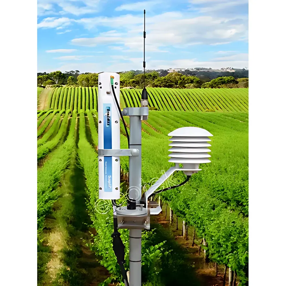
The Dynamax SapIP-MICRO Microclimate Monitoring Network is a modular, wireless mesh-based environmental observation system engineered for high-resolution spatiotemporal characterization of microclimatic gradients at field, orchard, vineyard, urban canopy, and ecotone scales. Unlike conventional centralized weather stations, the SapIP-MICRO employs a distributed architecture grounded in the SapIP wireless sensor network protocol—leveraging peer-to-peer LoRa communication to eliminate dependency on fixed cabling or proximity to a central logger. Each SapIP node functions as an autonomous data acquisition unit with integrated environmental sensing, onboard computation, non-volatile storage, and adaptive radio transmission. The system is purpose-built to quantify localized atmospheric and edaphic variables—including air temperature and humidity, solar irradiance, wind vector, precipitation, soil moisture, and soil temperature—and to derive physiologically relevant indices such as reference evapotranspiration (ET0) using the FAO-56 Penman-Monteith equation. Its design prioritizes long-term unattended operation in remote or spatially heterogeneous environments, with robust power management, IP67-rated enclosures, and field-configurable sampling intervals from 1 minute to 24 hours.
Key Features
- Self-organizing, self-healing wireless mesh topology supporting up to 25 nodes per network—no master-slave hierarchy required
- Dual connectivity options: SPIP-24K radio module for local mesh relay (300–500 m inter-node range) or SPIP-CELL cellular modem for direct cloud upload (LTE-M/NB-IoT compatible)
- Integrated 8-channel differential analog input interface enabling seamless integration of third-party sensors compliant with 0–2.5 V, 0–5 V, or 4–20 mA outputs
- Onboard flash memory capacity of 30,000 timestamped records; automatic circular buffer overwrite policy ensures continuous data continuity during transient connectivity loss
- Field-deployable power architecture: 7 Ah sealed lead-acid battery paired with a 10 W monocrystalline solar panel—validated for >12 months autonomy under typical mid-latitude insolation profiles
- Firmware-level ET0 calculation using standardized meteorological inputs and configurable crop coefficients—output aligned with FAO-56 guidelines
- IP67-rated enclosure rated for continuous operation across −40 to +70 °C ambient temperatures and 0–100 % RH
Sample Compatibility & Compliance
The SapIP-MICRO is designed for deployment in regulatory-compliant environmental monitoring workflows. While not certified as a Class I medical device or industrial safety instrument, its sensor suite meets performance benchmarks referenced in ASTM D5098 (soil moisture), ISO 9060:2018 (pyranometer classification), and WMO Guide to Meteorological Instruments and Methods of Observation (CIMO Guide, Chapter 12). Sensor calibrations are traceable to NIST standards where applicable (e.g., thermistors, platinum RTDs). Data integrity protocols—including timestamping with onboard RTC (±2 ppm accuracy), CRC-32 frame validation, and write-verified flash storage—support GLP-aligned data provenance requirements. When deployed with Agrisensors cloud services, audit trails, user role permissions, and session logging conform to foundational principles of FDA 21 CFR Part 11 for electronic records and signatures, though formal validation remains the responsibility of the end-user organization.
Software & Data Management
Data acquisition, visualization, and analysis are unified through the Agrisensors web platform—a secure, role-based SaaS application built on modern web standards (HTML5, RESTful APIs, PostgreSQL backend). Users authenticate via TLS-encrypted HTTPS sessions and gain access to real-time dashboards, time-series plots, multi-parameter correlation matrices, and exportable CSV/JSON datasets. Geospatial context is delivered via embedded interactive mapping (Leaflet.js), allowing users to overlay station locations on satellite basemaps and annotate site-specific metadata (canopy height, soil texture, land use). The platform supports custom alerting rules (e.g., “notify if RH 6 h”), automated report generation (PDF/Excel), and API-driven integration with third-party GIS or modeling tools (e.g., SWAT, CropSyst, WRF). All raw and processed data reside in georedundant AWS S3 storage with daily incremental backups and versioned object retention policies.
Applications
- Urban heat island (UHI) studies requiring sub-hectare thermal and humidity gradient mapping
- Precision viticulture and orchard management—correlating microclimate variability with phenological stage, disease pressure, and irrigation scheduling
- Validation of satellite-derived land surface temperature (LST) and evapotranspiration products (e.g., MOD16, SSEBop, METRIC)
- Boundary-layer meteorology research in complex terrain or forest–grassland ecotones
- Integration with parallel SapIP-SM soil moisture networks and SapIP stem flow systems to close water balance budgets at plot scale
- Early-warning deployment for convective initiation forecasting in low-instrumentation regions
FAQ
What is the maximum number of SapIP-MICRO nodes that can operate within a single mesh network?
Up to 25 independent nodes may be deployed in one self-organizing mesh network when using the SPIP-24K radio module.
Can SapIP-MICRO operate without internet connectivity at the field site?
Yes—the system operates autonomously with local data storage and mesh relaying; internet connectivity is only required for cloud synchronization via gateway or SPIP-CELL.
Is Agrisensors platform accessible outside China?
Yes—Agrisensors is a globally hosted service accessible via standard web browsers from any jurisdiction with HTTPS-enabled internet access.
Does the system support custom sensor integration beyond the factory-configured suite?
Yes—its 8-channel differential analog input interface supports calibrated third-party sensors meeting voltage/current output specifications and signal conditioning requirements.
How is time synchronization maintained across distributed nodes?
Each SapIP node uses a temperature-compensated real-time clock (TCXO) with ±2 ppm accuracy; periodic synchronization occurs during successful gateway or cloud handshakes.