SMC1800 Automated Soil Moisture Monitoring System
| Origin | Beijing, China |
|---|---|
| Manufacturer Type | Authorized Distributor |
| Product Origin | Domestic (China) |
| Model | SMC1800 |
| Instrument Type | Soil Moisture and Water Potential Analyzer |
| Sensor Principle | Frequency Domain Reflectometry (FDR) |
| Moisture Range | 0–100% vol |
| Temperature Range | −20 to +60 °C |
| Moisture Accuracy | ±2% (unsaturated zone), ±1% repeatability |
| Temp. Accuracy | ±0.3 °C |
| Resolution | 0.1% vol |
| Response Time | <2 s |
| Power Supply | 5–12 VDC |
| Operating Temperature | −20 to +50 °C |
| Data Storage Capacity | 5,440 records (e.g., 226 days at 1-hr interval) |
| Communication | GPRS, RS-232/RS-485, WSN-compatible |
Overview
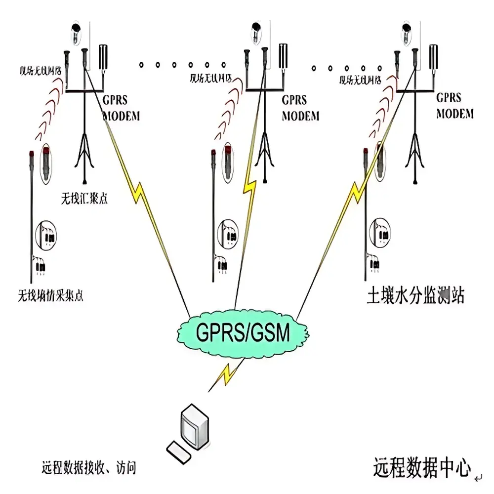
The SMC1800 Automated Soil Moisture Monitoring System is a field-deployable, multi-tier environmental telemetry platform engineered for long-term, high-reliability soil water content surveillance across heterogeneous landscapes. Built upon Frequency Domain Reflectometry (FDR) sensor physics, the system quantifies volumetric water content (θ, % vol) by measuring the dielectric permittivity of soil matrices—enabling non-destructive, in-situ assessment independent of soil texture, salinity, or bulk density within validated operational bounds. Unlike point-contact tensiometric or capacitance-based legacy systems, the SMC1800 architecture decouples sensing, aggregation, and transmission into modular, solar-powered nodes—supporting scalable deployment from single-plot agronomic trials to province-wide ecological observatories. Its design adheres to fundamental principles of hydrological monitoring: minimal soil disturbance, temporal fidelity (sub-second sensor response), and metrological traceability via factory-calibrated FDS120 probes compliant with ISO 11274 and ASTM D7928 guidelines for field moisture instrumentation.
Key Features
- Modular hierarchical topology: Independent sensor nodes (FDS120), wireless edge aggregators (SMC1680), and GPRS-enabled central RTUs (SMC1800) operate as interoperable layers—eliminating cable dependency and enabling >1 km inter-node radio range in open terrain.
- Ultra-low-power telemetry: Intermittent sensor excitation (only during measurement cycles) prevents electrochemical polarization and preserves native soil physicochemical equilibrium; sleep-mode current draw <0.05 mA extends battery life beyond 6 months on standard alkaline cells.
- Onboard data resilience: Local storage of 5,440 timestamped records (year-month-day-hour-minute-second format) ensures continuity during network outages; configurable logging intervals from 1 minute to 30 days.
- Ruggedized sensor construction: FDS120 probes feature 316L stainless-steel electrodes (6 cm length), IP68 ingress protection, and mechanical robustness to withstand compaction, freeze-thaw cycles, and rodent activity without signal drift.
- Flexible power architecture: Integrated solar charging controller, 12-bit A/D conversion (0.6 mV resolution), 8-channel analog input, and 8 programmable power outputs enable mixed-sensor deployments (moisture, temperature, EC, matric potential).
Sample Compatibility & Compliance
The SMC1800 system accommodates diverse soil types—including clay loam, sandy loam, peat, and volcanic ash—within its validated 0–100% vol moisture range. FDS120 sensors are calibrated per ISO 11274 Annex B protocols using gravimetric reference standards and verified against NIST-traceable humidity chambers. All electronics comply with IEC 61326-1 (EMC for industrial environments) and RoHS 2011/65/EU. Data integrity meets GLP-aligned audit requirements: each record embeds immutable UTC timestamps, sensor ID, and firmware revision; optional software modules support 21 CFR Part 11-compliant electronic signatures and change-controlled audit trails for regulated agricultural research or environmental impact assessments.
Software & Data Management
The system’s Windows-based upper-layer software provides real-time dashboard visualization, georeferenced map overlays, automated anomaly detection (e.g., rapid θ decline indicating subsurface drainage), and export to CSV, NetCDF, or SQL databases. Remote interrogation capability allows on-demand polling of any node—bypassing scheduled intervals for event-triggered sampling (e.g., post-irrigation or rainfall events). Custom scripting interfaces (Python API, Modbus TCP) support integration with third-party platforms including CropX, FieldView, or national hydrological databases (e.g., China Meteorological Administration’s CMA-SoilNet). All firmware updates are delivered over-the-air via encrypted GPRS channels.
Applications
- Regional-scale ecological monitoring: Continuous θ profiling across distributed flux towers and long-term ecosystem research sites (e.g., China Ecosystem Research Network—CERN).
- Linear infrastructure management: Real-time moisture trending along highway embankments, railway cuttings, and river levees to inform slope stability models and early-warning thresholds for mass wasting.
- Precision agriculture: Zone-specific irrigation scheduling based on root-zone depletion metrics derived from multi-depth FDS120 arrays (up to 8 sensors per node).
- Geotechnical risk mitigation: Co-located θ and temperature logging in landslide-prone mountainous terrain to correlate antecedent moisture conditions with pore-pressure buildup.
FAQ
What communication protocols does the SMC1800 support for integration with existing SCADA systems?
It natively supports Modbus RTU over RS-485 (up to 1 km), Modbus TCP via Ethernet-to-GPRS bridge, and custom ASCII protocols via configurable serial framing—enabling direct ingestion into Siemens Desigo, Schneider EcoStruxure, or Ignition SCADA environments.
Can the system operate reliably in high-salinity soils?
Yes—the FDS120’s FDR methodology exhibits lower sensitivity to electrical conductivity (EC) than TDR or capacitance methods; validation data confirm <±3% θ deviation up to 8 dS/m EC at 25 °C, per ASTM D7928 Annex A.
Is cloud-based data hosting available?
The base software includes local server deployment; optional managed cloud service (AWS IoT Core backend) provides TLS 1.2 encryption, role-based access control, and automated backup—fully compliant with ISO/IEC 27001 information security standards.
How is sensor calibration maintained over multi-year deployments?
Each FDS120 carries a unique calibration certificate referencing NIST SRM 1692 (soil moisture standard); field recalibration is performed annually using in-situ gravimetric samples collected per ISO 11274 Section 6.2 procedures.
Does the system meet regulatory requirements for environmental reporting?
Data exports include ISO 8601 timestamps, sensor metadata, and uncertainty estimates—satisfying reporting mandates under China’s HJ 630-2011 Environmental Monitoring Technical Specifications and EU INSPIRE Directive Annex III (Soil Theme).


